Might be a lot like the old boss
By
Will Collette
 Dale
Faulkner reported
in today’s Westerly Sun that Rawson Materials of Putnam, CT has made a deal
to acquire several controversial area quarries with an eye toward more
stripmining.
One
of those properties is what most of us in the area still call the Copar Quarry
on the Westerly-Charlestown town line.
The site, owned by the
politically-connected Comolli family, had been leased to Copar, later called
Armetta Sand and Stone.
The lease was transferred to Cherenzia, Co. after
Copar-Armetta imploded and went bankrupt in 2015.
To
put it mildly, the Copar-Armetta operation made the lives of its neighbors
miserable for the duration of its operations. CLICK
HERE for all our coverage of the Copar story and related issues.
Cherenzia
sold two of its Westerly quarries to Rawson Materials outright and transferred
its lease for the Copar site to Rawson.
So
what’s in store for the neighbors in Charlestown and Westerly? If the past is
any indication, they may be due to get more of the same from Rawson.
For
example, just last year, the state of Connecticut took enforcement action on Rawson for fugitive
dust: http://www.ct.gov/deep/lib/deep/enforcement/consentorder/COAR2390.pdf
Then
there’s the 2015 settlement with Canterbury, CT: http://www.norwichbulletin.com/article/20151011/NEWS/151019948
on notices of violation: http://www.canterburyct.org/documents/1-3-14-13.pdf
Also
in 2015, allegations of an illegal deal in Brooklyn, CT: http://www.norwichbulletin.com/article/20150911/NEWS/150919869
And
in 2010, breach of contract: https://casetext.com/case/neundorf-v-river-junction-no-wwm-cv08-5003741s-aug
This
latest news begs the question: haven’t we learned our lesson about the problems
quarries can cause in populated areas? Haven’t we learned the value of doing
due diligence on operators of business that can have such a major impact on the
community?
Why
is it that neither Westerly nor Charlestown have adopted “bad
actor” policies to prevent the town from issuing permits and business licenses
to known offenders?
What
ever happened to Westerly’s commendable idea of buying
the Copar quarry to set it aside as open space?
We
were just introduced to Rawson Materials this morning so what we have so far
probably just scratches the surface. To add to what we know, check out this 2016
EcoRI coverage of Rawson’s environmental practices.
By FRANK CARINI/ecoRI News staff, 6
 |
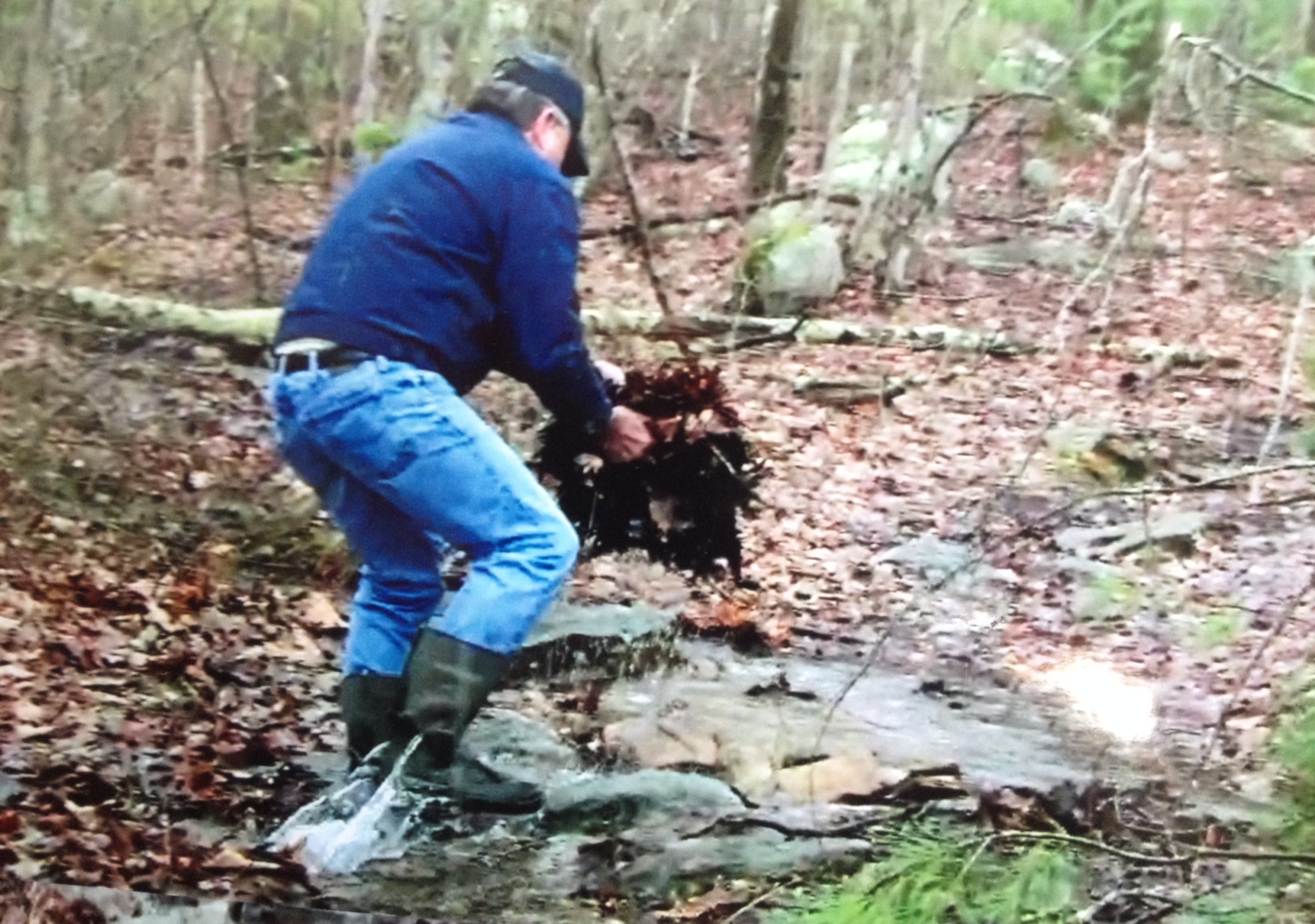
| Connecticut resident Allan Rawson, managing member of Putnam-based River Junction Estates, was recently videotaped moving rocks and leaves along a watercourse in Rhode Island’s Buck Hill Management Area. (Rob Mann photos) |
THOMPSON, Conn. — For more
than a year, the town’s Inland Wetlands Commission, Planning & Zoning
Commission and Board of Selectmen have been holding hearings and meetings
regarding requests to alter wetlands near Rhode Island’s Buck Hill Management
Area.
Two applications have been
filed in the past year, by the same party, to develop parts of the same parcel,
about 112 acres of subdivided land near the intersection of the Connecticut,
Rhode Island and Massachusetts borders. The first application, which the town
denied, called for building a bridge and gravel driveway into the woods. The
owner of the land, River Junction
Estates LLC, said it wanted to open up the space for hikers.
The property is nestled
between the Buck Hill Management
Area and Connecticut’s Air
Line State Park Trail. Hikers can access the area in question from
multiple trails in both nature preserves.
The area has been deemed
“unbuildable,” and the only access to the property from the end of Starr Road
is through private property, according to various maps and documents.
The property sits northwest
of Starr Road, and the 0.15-mile town road that ends in a cul de sac is at the
heart of the ongoing issue. Abutters to the River Junction Estates (RJE)
property call the dirt path that begins at the end of paved Starr Road a trail
and note its intermediate water flow; Allan Rawson of RJE and his attorney
claim it once was used as a road and under Connecticut state law still is.
The designation of that
path, and who is entitled to access it besides the two abutting neighbors, is
at the crux of the ongoing debate. Town attorney William St. Onge has noted
that there are a number of opinions regarding the dirt path.
At a public hearing in
January, the Hartford
Courant reported that St. Onge told the Inland
Wetlands Commission that, “As the town attorney, I don't feel
the section of Starr Road beyond the cul de sac to the Rhode Island line is a
town road of Thompson at this time.”
Allan Rawson, left, told a Connecticut radio station that,
‘Anything that was done was returned to the condition that it was before we
went there.’
The path hasn’t been on town
road records or maintained by the town in more than six decades, according to
St. Onge. Various maps dating back to 1956 refer to the dirt path after Starr
Road as abandoned or impassable.
Rawson and his attorney
believe otherwise, however, claiming the dirt path has long been a public road.
In an April
19 letter to the Board of Selectmen, Rawson's attorney, Stephen
Penny, writes that in 1977 Starr Road was a gravel road all the way to the
Rhode Island border.
A group of about dozen
neighbors have argued that the access point to the dirt path is legally owned
by two families who abut the property. The abutters have hired a attorney. A
court will likely decide.
RJE’s second applications is
asking the town permission to build water diversions on the property.
The
attorney representing the abutting landowners has said RJE hasn’t given
sufficient reasons as to why it plans to divert water for proposed development
near the disputed dirt path.
Rawson’s father founded Rawson Materials,
a quality aggregate producer, in 1947, and the business currently runs a mining
operation not far from the area in question. Rawson has told the town he has no
plans to mine gravel on the RJE property.
To further complicate the
issue, Rawson and another man were photographed and videotaped earlier this
month altering wetlands within the Buck Hill Management Area.
In the April 8 video — shot
by Thompson resident Rob Mann who has been documenting water flow in the Starr
Road area for several months — Rawson can be seen moving rocks and leaves. Mann
hasn’t made the video public, but he did allow ecoRI News to watch it.
In response to an ecoRI News
request for comment about the ongoing issue and the recent video, Rawson's son
Jeffery, president of Rawson Materials, e-mailed us Penny's April 19 letter to
selectmen. The letter doesn't address Mann's recently shot video.
Mann became interested in
the issue last year, after a few contentious hearings and allegations of
document/map forgery at Town Hall. He said he was as surprised as Rawson when
they bumped into each other in the Rhode Island woods.
“He was moving rocks and
leaves to change the flow of water,” Mann said. “What else could he be doing?”
Water flow on and around the
dirt path area is a point of contention in the ongoing case.
Mann has filed a complaint with
the Environmental Protection Agency, the Connecticut Department of Energy and
Environmental Protection and the Rhode Island Department of Environmental
Management, among other agencies. His five-page letter claims “Mr. Allan Rawson
and his Connecticut Licensed Engineer were altering and re-routing the water
flow of this stream channel collectively ... all without proper permits from
the required agencies.”

When asked by Connecticut
radio station WINY (1350-AM) if
he went through the legal processes necessary to alter the watercourse, Rawson
said, “Yeah, that's certainly not a problem with what I did. Anything that was
done was returned to the condition that it was before we went there.”
Rawson also made it clear
that Rhode Island authorities, who he confirmed will be investigating the
matter, knew what he and his engineer were doing in the nature preserve,
according to WINY.
ecoRI News retraced Mann’s
steps with him on April 15. It had been a few days since it rained, but water
was flowing on parts of the dirt path in Connecticut. Around the path were
vernal ponds, multiple water channels, natural springs and wetlands vegetation.
“The water runs way beyond a storm
event,” Mann said. “Water runs five to six months out of the year here. It’s
likely salamander breeding ground.”