Warmed up and ready to go
By Michael Carlowicz
 |
| NASA Earth Observatory image by Lauren Dauphin, using data from the Multiscale Ultrahigh Resolution (MUR) project. |
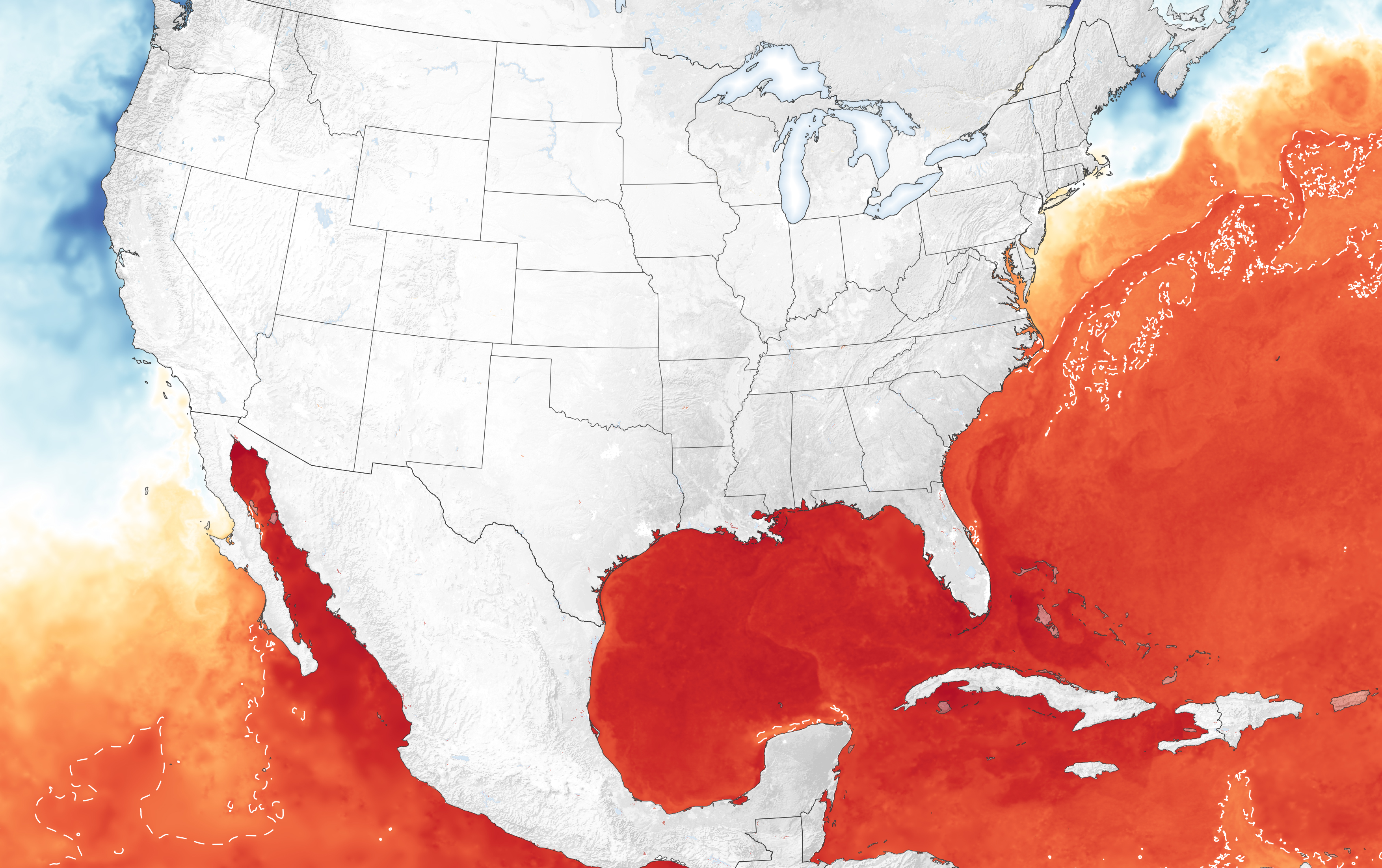
Heading into the peak of hurricane season, the seas around North and Central America are primed to fuel storm development and intensification in the Atlantic and Eastern Pacific. While sea surface temperatures are just one factor influencing the development of hurricanes, they are a fair predictor of the readiness of the ocean to sustain them.
The map above shows sea surface temperatures (SSTs) as measured on
August 11, 2021, by a combination of satellite and ocean instruments.
Meteorologists generally agree that SSTs above 27.8° Celsius (82° Fahrenheit) intensify and
sustain hurricanes, cyclones, and typhoons. Surface waters
above that threshold are represented in red on the map. Note the finger of warm
water—the Gulf Stream—running parallel to the U.S. East Coast.
The data for the map come from the Multiscale Ultrahigh Resolution sea surface temperature analysis, produced at NASA’s Jet Propulsion Laboratory. It is based on observations from several satellite instruments, including the NASA Advanced Microwave Scanning Radiometer-EOS (AMSRE), the Moderate Resolution Imaging Spectroradiometer (MODIS) on the NASA Aqua and Terra platforms, the U.S. Navy microwave WindSat radiometer, the Advanced Very High Resolution Radiometer (AVHRR) on several NOAA satellites, and from in situ observations from NOAA.
The 2021 hurricane season started quickly. In May, Tropical Storm
Andres became the earliest named storm—winds of 39 miles per
hour or greater—on record in the Eastern Pacific. To date, eleven tropical
storms have developed in the basin, including four hurricanes.
In the Atlantic, five named storms formed between May 19 and July 9, with Hurricane Elsa becoming the earliest fifth named storm on record. After Elsa, the Atlantic remained quiet until Tropical Storm Fred emerged on August 11.
The storm lost some
strength while passing near Haiti, the Dominican Republic, and Cuba, but it is
forecasted to regain tropical storm force before making landfall in Florida
over the weekend. Forecasters
warned citizens about the potential for heavy rainfall.
In its mid-season update on August 4, scientists from the NOAA Climate Prediction Center forecasted 15 to 21 named storms in the Atlantic in 2021, including 7 to 10 hurricanes, of which 3 to 5 could become major hurricanes.
They noted:
“Atlantic sea surface temperatures are not expected to be as warm as they were
during the record-breaking 2020 season; however, reduced vertical wind shear
and an enhanced west Africa monsoon all contribute to the current conditions
that can increase seasonal hurricane activity.”
NOAA and other federal and state agencies lead the forecasting of and response to hurricanes in the United States, with NASA playing a supporting role in developing experimental tools and providing key data to those agencies.
NASA also works to streamline the flow of information to international science institutions, governments, and aid groups as they use and customize data products from freely available NASA data.
“The NASA Disasters program contributes
with high-value or unique products that complement actions of operational
agencies and regional governments, support decision-making during crises, and
aid in disaster risk reduction,” said Ricardo Quiroga,
who coordinates with regional teams in Latin America through his role as
co-lead of the AmeriGEO
Disasters Working Group.
NASA Earth Observatory image by Lauren Dauphin, using data from
the Multiscale Ultrahigh Resolution (MUR)
project. Story by Michael Carlowicz.